Searching for Blind Faults: Subsurface Imaging in Haiti
Wavelets Article in March GSH Journal
By Eray Kocel, Robert Stewart, and Azie Aziz
 On January 12, 2010, Haiti suffered a major earthquake (Mw = 7.0) causing tragic loss
of life as well as infrastructure. While the epicenter of the event was located by
the worldwide network of seismic stations, no surface expression of the earthquake
fault has yet been unambiguously identified. Thus, key geologic components of the
devastating rupture are not well understood. The Haiti Subsurface Imaging (HASI) Project
(led by the University of Houston and supported by Geoscientists Without Borders,
TGS, and the SEG Foundation) aspires to find expression of this “blind” fault. We
have made two geophysical reconnaissance surveys in Haiti to date: undertaking ten
days of seismic, GPS, and gravity surveys in the epicentral Léogâne Delta region (2012
and 2013 surveys) as well as GPS and gravity surveys near Port-au-Prince (2013 surveys).
The primary goals of the HASI project are to: a) assist in continuing to build Haiti’s
geoscientific and hazard-assessment capabilities, b) characterize the physical properties
of the epicentral region’s near-surface sediments, and c) find geophysical evidence
of the fault(s) that are thought to have given rise to the 2010 earthquake.
On January 12, 2010, Haiti suffered a major earthquake (Mw = 7.0) causing tragic loss
of life as well as infrastructure. While the epicenter of the event was located by
the worldwide network of seismic stations, no surface expression of the earthquake
fault has yet been unambiguously identified. Thus, key geologic components of the
devastating rupture are not well understood. The Haiti Subsurface Imaging (HASI) Project
(led by the University of Houston and supported by Geoscientists Without Borders,
TGS, and the SEG Foundation) aspires to find expression of this “blind” fault. We
have made two geophysical reconnaissance surveys in Haiti to date: undertaking ten
days of seismic, GPS, and gravity surveys in the epicentral Léogâne Delta region (2012
and 2013 surveys) as well as GPS and gravity surveys near Port-au-Prince (2013 surveys).
The primary goals of the HASI project are to: a) assist in continuing to build Haiti’s
geoscientific and hazard-assessment capabilities, b) characterize the physical properties
of the epicentral region’s near-surface sediments, and c) find geophysical evidence
of the fault(s) that are thought to have given rise to the 2010 earthquake.
Faculty, staff, and students from the University of Houston have worked with graduate students from Haiti’s National University and geoscientists from the Haitian Bureau of Mines and Energy (Figure 1). This collaboration has provided an excellent platform to understand Haiti’s geology and hazards, help building technical capacity, assist with the development of Haitian personnel, and provide an international experience for students.
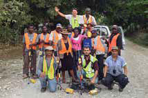
Figure 1: Haitian and Houstonian geophysical research team after completion of 2013
Léogâne seismic surveys.We have used two different seismic recording systems in Haiti: the autonomous nodes
(GSRs generously loaned to us by Global Geophysics) and cabled recorders (Geometrics’
Geodes). In addition, we had various sources: a sledge hammer for the 2012 surveys,
then the GISCO accelerated weight drop (slanted to excite both P and S waves) as well
as the Propelled Energy Generator for the 2013 surveys (Figure 2).
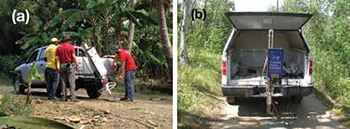
Figure 2: Seismic sources in Haiti: a) Vertical accelerated weight drop source (PEG),
b) Slanted accelerated weight drop (GISCO) on the line.These reconnaissance surveys delivered reasonable seismic data (Figure 3). Several hundred millisecond seismic data is imaging up to about 300 m depth. Migrated
sections from both years showed disruptions and discontinuities in the reflectors.
However, from the earthquake’s hypocentral location and magnitude, we anticipate that
the top of the blind fault could be some several kilometers deep. While our shallow
seismic lines showed some evidence of faulting, the images were not clear enough and
the discontinuities were not necessarily part of the larger fault system required
to create the 2010 earthquake. Thus, to further develop Haitian geophysical capabilities
and create more detailed and deeper seismic sections, we plan to return to Haiti in
March, 2014 with a larger seismic source and more recording channels. With Haitian
help, we hope to illuminate the blind fault, better understand the Haitian subsurface,
and assist in advancing Haiti’s technical capabilities.
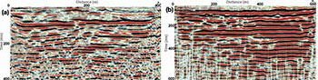
Figure 3: a) P-wave time migrated section using a hammer source and cabled vertical
geophones, b) P-wave time migrated section using vertical weight drop and cabled vertical
geophones. Some disruptions in the reflector continuity may be indicative of faulting.NOTE: This article first appeared in the March 2014 issue of the Geophysical Society
of Houston’s GSH Journal. Republished with permission from GSH.